
How to Navigate the Temporary Closure of Cape Arago Highway
UPDATED February 10, 2025: Cape Arago Highway (Oregon Route 540) has been repaired and is now open to all vehicle traffic! All State Parks and hiking trails impacted by the damage in early January and are open to the public and accessible by vehicle.
Cape Arago Highway (Oregon Route 540) Closure: What It Means for Visitors to Shore Acres and Cape Arago State Parks…for Now.
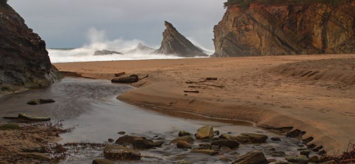
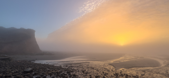
The state parks and undeveloped beaches along the Cape Arago Beach Loop are among the most cherished destinations on the Oregon Coast. Known for their scenic trails, beaches, and wildlife, including seals and sea lions, these parks showcase the true beauty of Oregon’s Adventure Coast: Coos Bay, North Bend, and Charleston.
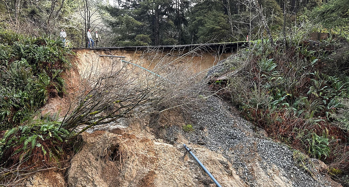
By now, you probably have heard about the extreme flooding and the small landslide in early January that damaged a section of the Cape Arago Beach Loop, temporarily limiting vehicle access to Shore Acres and Cape Arago State Parks . In this post, we’ll share the latest updates, answer common questions, and suggest alternatives for enjoying these beautiful state parks on Oregon’s South Coast this winter.
Here is what we know so far:
- On January 3, 2025, heavy rain and flooding caused a landslide that undercut a section of Cape Arago Highway (Oregon Route 540) near Norton’s Gulch, between Sunset Bay State Park and Shore Acres State Park.
- The landslide caused significant roadway damage but fortunately resulted in no injuries.
- Oregon Route 540 is temporarily closed to vehicle traffic, cutting off vehicle access to Shore Acres and Cape Arago State Parks. The road closure is past the entrances to both the Sunset Bay Campground and the Sunset Bay Golf Course.
- The Sunset Bay State Park day-use area remains open and accessible by vehicle, unaffected by the landslide. While the campground initially closed due to flooding, it has since reopened to campers, though availability may change with weather conditions.
- The Oregon Parks and Recreation Department (OPRD) is working with contractors and engineers to assess the damage and determine repair timelines for Cape Arago Loop. No estimated completion date is available yet.
- Hiking trails along Cape Arago Highway, including a portion of the Oregon Coast Trail, remain open and safe for use. Visitors will still be able to access the Bog Trail between the campground and Yoakam Point, the day-use areas of Sunset Bay, and the portion of the Oregon Coast Trail (OCT) that goes from South Sunset Bay Day Use to Norton Gulch.
OPRD spokesperson Lee Ricci emphasizes the importance of keeping visitors informed about potential risks while encouraging safe access to the parks. Below, we address some of the most common questions regarding the road closure and its impact on the trails, beaches, and state parks along the Cape Arago Beach Loop. Here are some answers to some of your questions:
Is the entire Cape Arago Highway loop closed? No, only the section south of Sunset Bay State Park leading to Shore Acres and Cape Arago State Parks is closed. The following destinations remain open and accessible by vehicle:
- Charleston Marine Life Center
- Charleston Marina
- Bastendorff Beach
- Sunset Bay State Park
- Sunset Bay Golf Course
How long will this section be closed? Repair work has begun, but OPRD does not have an official ETA for when the road will be reopened to the public. We will share that information through our official channels when we know something.
Are the state parks open? Shore Acres and Cape Arago State Parks are currently inaccessible, but all other state parks and national lands on Oregon’s Adventure Coast: Coos Bay, North Bend, Charleston are open.
Can I go camping in the Sunset State Park campground? Yes, the Sunset Bay State Park campground has reopened after a temporary closure due to heavy rain and flooding. However, conditions are subject to change, so visitors should check with Oregon State Parks or call the reservation line for updates.
Are the trails from the parking lots at Sunset Bay open? Yes, the trails are open and in surprisingly good condition despite the recent heavy rain and flooding. For an abbreviated exploration of the Oregon Coast Trail, take the 2.25 mile round trip hike from Sunset Bay State Park day use area to Norton Gulch and back. There are plenty of interesting coves to explore along the trail.
What about bathrooms? Bathrooms at Sunset Bay are open during their usual hours. At Shore Acres, the restrooms, garden area, and gift center are closed, but portable toilets are available for thru-hikers.
Can I access Shore Acres or Cape Arago by foot or bike? No, the road is closed to all vehicle, bike, and foot traffic.
What About Storm-Watching? If you want to view the high surf and dramatic waves from Shore Acres and Cape Arago State Parks, you will have to walk there via the OCT from Sunset Bay State Park as mentioned above. However, hikers should exercise extreme caution. Emergency services may have difficulty reaching these areas due to road closures, so travel at your own risk. For your safety, stay on marked trails, avoid cliffs and unmarked areas, and keep a distance from the water. Bring a buddy, inform someone of your plans, and share your expected return time.
For easier access by vehicle, consider these alternative storm-watching locations:
- Bastendorff Beach Bluff: Offers fantastic views of the ocean from a safe, elevated location.
- Sunset Bay State Park: A convenient spot for wave-watching near the day-use parking area.

**Safety Tips for Storm Watching during High Surf Events**
- Check weather forecasts and tide charts to ensure safety during high surf events.
- Stay on marked trails and avoid getting too close to cliffs or beaches.
- Stay away from the water and from logs.
- Stay off the Jetties.
- Always keep the ocean in view and never turn your back to it.
- Monitor news reports and posted warnings.
- Know your escape route in case of rising water.
- Avoid standing near cliffs.
- Always watch for sneaker waves and unstable ground, especially near cliffs.
- Dress warmly and bring waterproof gear to stay comfortable in the elements.
Looking for Alternatives?
There are plenty of other destinations along the Charleston to Bandon Tour Route that offer beautiful vistas and unique experiences. Bring your camera and take lots of photos!
South Slough National Estuarine Research Reserve (SSNERR)-This south coast gem is home to diverse marine life, including shellfish, salmon, and seabirds. The South Slough National Estuarine Research Reserve features a variety of hiking and paddling trails that wind through estuarine habitats, as well as an informative interpretive center.
Seven Devils State Recreation Site - Located just 26 minutes (20.1 miles) south of Coos Bay via US-101 S and W Beaver Hill Road, Seven Devils State Recreation Site is a hidden gem in Coos County offering panoramic views and a vast, uncrowded beach where you can often feel at one with nature. Beachcombers will delight in finding driftwood, agates, rocks, and small shells scattered along the shoreline.
Whiskey Run Beach -Just five minutes from Seven Devils State Recreation Site, Whiskey Run Beach offers a wide, sandy shoreline and a peaceful escape from crowds. Fun fact: the beach was a smuggling route during Prohibition, giving it its unique name. Perfect for a leisurely stroll, rockhounding, or enjoying the natural beauty, Whiskey Run Beach delivers a classic Oregon Coast experience.
To learn more and plan your adventure, order a free Oregon Scenic Byways guide , or visit our Cape Arago Highway Loop andCharleson to Bandon Tour Route itinerary pages.
Whether you’re looking for the perfect place to lay your head after a long day of hiking or an excellent spot to unwind with a local brew, we’re here to help! The volunteers and staff in the Coos Bay and North Bend Visitor Centers are always glad to help you plan and get the most out of your trip! Give us a call at (541) 269-0215 or info@oregonsadventurecoast.com .